 By Bill Haviland
From Maine Insights News
One of the more important of this region’s waterways is the Bagaduce River. For at least 2,000 years, it served native people as a major transportation artery from the Penobscot River to the Reach. It was called Meniwoken (the many directions route) by the Indians who paddled to the river’s source in Walker’s Pond, avoiding the difficult waters off Cape Rosier. A short carry from the pond to the Punch Bowl, across from Little Deer, gave access to the Reach and the canoe routes of Deer Isle.
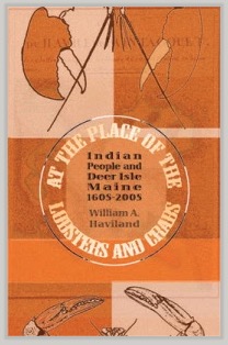
PHOTO: Bill Haviland’s Book Indian People and Deer Isle Maine sheds insights on Indians too.
The name Bagaduce is a corruption of an Indian word, Majabigwaduce, meaning “big tideway river.” Most people assume that this is the original name of the river, but it is not. The word is a Mi’kmaq (Micmac) one, but the Mi’kmaqs are not native to this region. Their homeland lies in Canada’s Maritime provinces and far northern Maine. So how did a Mi’kmaq name get applied to a river in midcoastal Maine?
What happened was that in the 16th century, the natives of Nova Scotia developed an important trade relationship with the French, from whom they got such things as copper kettles, iron axes, cloth, guns and ammunition. As this trade grew in importance, traditional trading relationships were disrupted. Moreover, Mi’kmaqs sought to solidify their favored position by raiding down the coast, eventually as far south as Massachusetts Bay. In this, they were aided by their quick mastery of French shallops (open vessels with one mast, about 20 feet long, that could be rowed or sailed), and their possession of French firearms. Local Indians reacted to these raids in two ways; those living east of Schoodic allied themselves with the Mi’kmaqs; those to the west with the Almouchiquois, who lived between the Kennebec and Merrimack Rivers. By 1600, the Mi’kmaqs and their allies controlled the coast all the way to Penobscot Bay, and in 1615 they defeated the head of the regional confederacy that had controlled the region from Schoodic to Cape Neddick. One of the staging areas for these raids was probably Isle au Haut, which Captain John Smith in 1614 referred to as “the Isle of Sorico.”
The French called the Mi’kmaqs Souriquois, and Smith’s Indian guide probably told him it was the “Isle of the Souriquois.” By the time this was filtered through the Indians’ accent and Smith’s English ears, it must have sounded like Sorico.
 The people native to the coast between the Kennebec and Saint John Rivers were Etchemins, whose name means “real human beings” (the Passamaquoddy word for themselves, Skidjim, is a modem version of Etchemin). In 1611, the Jesuit Pierre Biard met with a large group of Etchemins, including their most important chief (the one later overthrown by the Mi’kmaqs), near the mouth of what we call the Bagaduce. Their name for the river clearly was Chiboctous, meaning “big bay.” Specifically, it refers to protected inland bays connected to the sea by tidal channels, such as the great bays of the Bagaduce: the north and south bays in the present town of Penobscot. Such places were attractive to Indians, as the tide brought in food fishes, and the water was often open year round.
Today the old name for the river survives in the Passamaquoddy word Keipokotus, a slightly modified version of the original. The Passamaquoddies, for their,part, are descended from the eastern Etchemins.
This article first appeared in Island Ad-Vantages, May 18, 2006
